Most of us use GPS regularly, even if we are not all aware that we are doing so. But should we be concerned about its accuracy? In this post we consider when and how to go about improving GPS accuracy.
Some Terminology
Global Positioning System or GPS – a satellite-based navigation system owned and maintained by the United States government.
Global Navigation Satellite System or GNSS – any system of satellites transmitting data to receivers used to determine location. One such system is GPS, which is a term often used interchangeably with GNSS.
Real-Time Kinematic Positioning or RTK – a method to remove some of the inaccuracies inherent in GNSS systems.
How does GPS work?
GPS in our cars and our smartphones has revolutionised the way we get from A to B. Yet we often hear about people ending up in the wrong place. However, this is an issue with the correctness of the map data they are using, not the positional accuracy of the system.
When driving in your car, it doesn’t matter if the GPS is out by a few metres. But in some use cases, the imprecision of GPS data can be problematic. Before we consider those, let’s remind ourselves how GPS works.
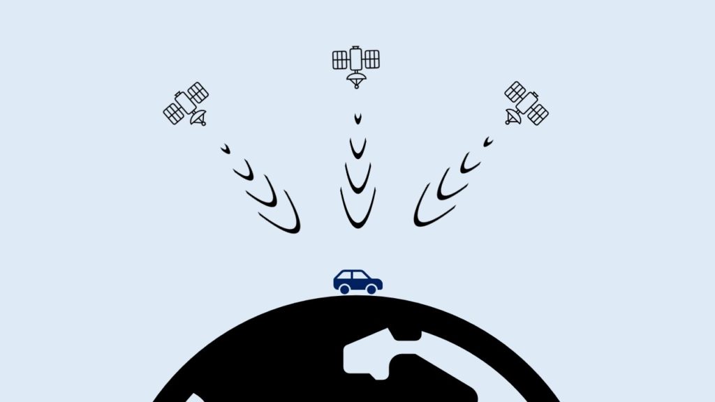
Each satellite in a GNSS transmits a unique signal picked up by your car, phone or some other type of GNSS receiver. When the receiver gets signals from enough satellites, it will use them to determine its whereabouts on the planet’s surface. This technique is known as trilateration, which is really well explained in the article How GPS Receivers Work on GIS Geography.
Over time, the satellites the receiver is seeing will change, as some go out of view and others appear. When we are in open, flat countryside the receiver will see more satellites than when blocked by buildings or natural features.
When is GPS not accurate enough?
As we mentioned earlier, for the majority of uses the accuracy of GNSS/GPS systems is good enough. If you want to see your current whereabouts on a digital map when out hiking or driving through town in your car, then out of the box GPS does a great job.
To give us a rough idea of accuracy, GPS.gov says that a GPS smartphone is typically accurate to within a 4.9m (16ft) radius. The quality of the GPS receiver, number of visible satelittes and atmospheric conditions all impact the accuracy of our receiver.
But what if that level of accuracy is not good enough? A farmer working in a field needs their tractor to go up and down in parallel lines, requiring centimetre accuracy. Similarly, when doing aerial or ground-based surveys we need high levels of accuracy.
Every photograph we take with a drone has its current coordinates and height above the ground written in to it. When reconstructing a scene using hundreds or thousands of such photos, the accuracy of this positional data is vital.
Improving GPS accuracy
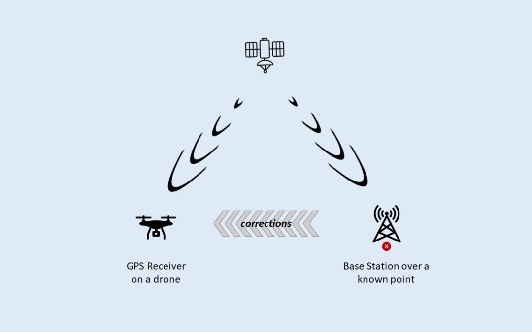
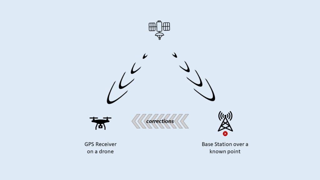
The accuracy of our GPS data is improved by applying corrections that are aquired and applied either in real-time (RTK) or by post processing (PPK). Each has their own benefits and drawbacks, but here we’ll focus on RTK.
Real-time corrections must come from a base station located nearby, so they see the same set of satellites. By placing a base station over a known point it can calculate the degree of error in the GPS trilateration and so corrections can then be sent to other receivers.
Once obtained, the receiver on board the drone or tractor applies these corrections to their own GPS calculations, improving the positional accuracy from metres down to centimetres.
Local vs Remote Base Stations
There are two options when it comes to base stations. Either setting up your own local base station over a known point, or connecting to someone elses over the Internet.
We’ll look at setting up a local base station first, as this is the simpler of the two options. You will need some additional equipment for this. At Fox Volant, we use an Emlid Reach RS2+, placed on a tripod over a known point. This point must either be calculated by the equipment or provided up front. Aside from the additional cost, one downside of a local base station is more equipment to carry about.
To use a third-party RTK corrections service requires access to the Internet. This is usually a paid service, although in some countires this is provided free by the state. The protocol used to transfer correction data over the Internet is called NTRIP. The article What is NTRIP? on the Anatum website gives a great overview of NTRIP.
The primary concern when using an NTRIP service is how close the remote base station is to where you are working. There are two reasons for this. Firstly, if they are too far away then you’ll be seeing different satellites, due to the curvature of the earth. The second reason is the difference in atmospheric conditions between locations. These can result in the wrong corrections being applied for your location.
In this post, we explain what point clouds are and why they’re becoming an increasingly important part of day to day life across a multitude of industries.
What are Point Clouds?
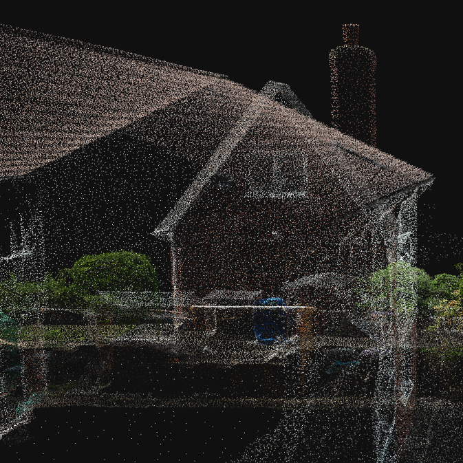
Put simply, a point cloud is a collection of data points in a three-dimensional space.
Let’s start with something simple like a seashell. If we take measurements of one hundred different points on the shell’s surface we can then plot each of those points in a virtual space to build a simple model. If we increase the number of measurements then the model becomes more detailed.
Now consider a much more complicated structure, such as the inside of your kitchen. Think of all the large surfaces such as walls, ceilings, floors, tables and worktops. Then add in all the objects on them such as plates, cups and bowls, to name a few. Everything visible in the room has surfaces that need to be captured and represented as points, requiring us to scale up to millions.
Collecting and storing all of these points together gives us a point cloud, which can then be saved as a file. A point cloud then gives us a detailed and accurate representation of an object or a complex structure. Each point can also have associated meta-information, such as colour or intensity.
How do we generate Point Clouds?
There are two common ways of generating a point cloud – Lidar or Photogrammetry.
Lidar (Light Detection and Ranging) uses pulses of light to measure the distance to an object. Your smartphone may have a Lidar sensor built-in, for example.
For a more in-depth explanation of LiDAR, check out A Complete Guide to LiDAR on the GIS Geography website.
Photogrammetry works by analysing hundreds or thousands of 2D images to determine where the points are in the three-dimensional space. These images are typically taken with a regular RGB (Red, Green and Blue) sensor camera.
Whilst the concept of a point cloud is relatively simple, they hold immense potential across a variety of industries. The following is by no means comprehensive, but tries to highlight some everyday uses for point clouds that impact our lives.
Architecture and Construction
The work of architects, engineers and construction professionals has been revolutionised by point cloud technology. Being able to capture the as-built state of structures as a point cloud enables accurate modelling and analysis.
This not only aids the design process for renovation or extension work, but also facilitates clash detection analysis. Making sure that new elements will fit seamlessly into existing structures and avoiding costly on-site corrections.
Surveying and Mapping
Traditional surveying methods can be time-consuming and labour-intensive. Point clouds offer a more efficient solution by rapidly capturing accurate topographical and geographical data. Another benefit is the ability to capture many more data points that can then be represented as a point cloud.
Once captured, accurate measurements then can be obtained from the point cloud. This is especially valuable in urban planning, land development, and environmental monitoring.
Cultural Heritage and Preservation
Conservationists meticulously document historical sites and artefacts as part of preservation efforts. These days, this will involve the creation of digital replicas recorded with a high degree of precision. Not only does this help in our understanding and aid restoration, but also provides researchers with an immersive way to explore our heritage.
A point cloud acts as a permanent record of the current state of a site. This can be compared against any previous or future scans of the same location. This allows them to check for any deterioration and helps determine if and where they need to do any remedial work.
Manufacturing and Quality Control
Scanning a physical object to create a point cloud allows the object to be compared alongside its digital design for reference. If the manufacturing process has introduced any deviations from the reference, then these can be picked up and the object rejected to ensure consistency. This greatly helps improve overall quality assurance.
Autonomous Vehicles
Some manufacturers of self-driving cars use Lidar generated point clouds to build up a model of the vehicle’s surroundings for the on-board computer to interpret. Training the computers to correctly interpret this data and then consistently determine the right course of action is the hard part.
We use the term orthomosaic on our website and in our posts, but what does it actually mean? In this post, we’ll try to explain in simple terms what an orthomosaic is, how we create them and what makes them so useful.
Why is an orthomosaic different from an aerial photo?
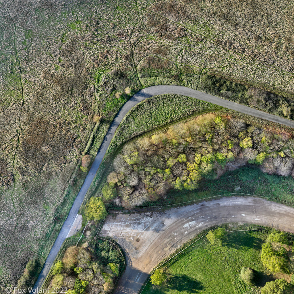
Let’s get started with the following image; a small section of an abandoned airfield.
It looks just like any other aerial photograph, doesn’t it? In fact, it’s an orthomosaic, computer-generated from hundreds of drone photographs, showing an area of about 6.5 acres. To capture a similar image with a single aerial photograph you’d probably need to fly above the legal maximum height for a drone (120m / 400 ft).
We begin with a process called orthorectification. This corrects the photographs that will make up the orthomosaic, converting them into orthophotos. The prefix ‘ortho’ means upright, straight, regular or true; so orthorectification is the term we use when geometrically correcting a photograph to be ‘true’.
Why do aerial photographs need to be corrected?
Imagine flying above where you live or work and trying to take a photograph straight down. Looking at the resulting photograph you might notice that the camera lens has introduced some distortion. Also, if it’s not pointing perfectly downwards you’ll also see a degree of tilt in the photograph. Orthorectification compensates for both.
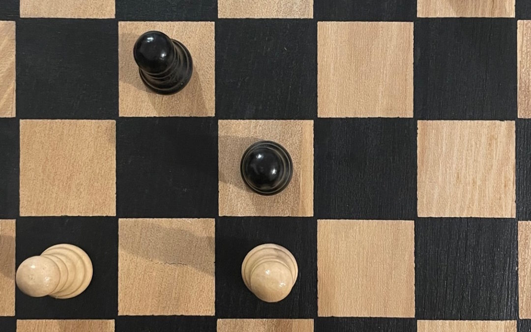
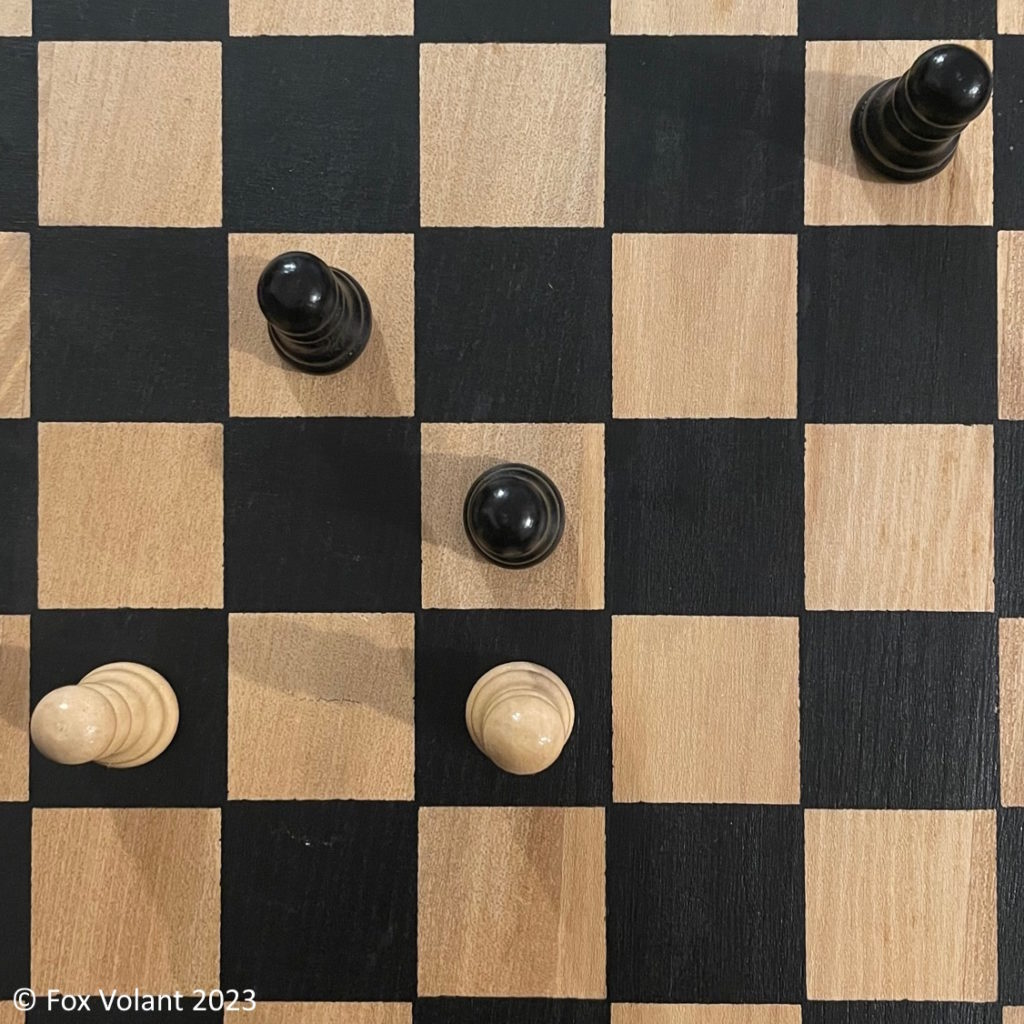
An example on a smaller scale
Look at the image of the chessboard shown below and you can see that both the top and base of the centre chess piece are clearly visible. As you move further away from the centre the pieces increasingly occlude themselves. In an orthorectified image, we would expect all the pieces to appear the same as the one in the centre.
How the orthomosaic process works
Photogrammetry software takes many overlapping images and calculates height data for all the points in our scene. The software then uses this data to create a Digital Surface Model (DSM), which represents the topography of the scene. We then use the DSM to orthorectify the photographs and join them together to make the orthomosaic.
The advantage of an orthomosaic
As we mentioned at the beginning of this post, using orthomosaics allows you to generate an image showing a very large area; in some cases covering tens or hundreds of acres in minutes with our drones. Without orthomosaics this would require using an aeroplane or even a satellite to take the photographs.
The other benefit of this process is accuracy. We can create maps of an area which contain precise measurements of the distances and angles of the topography. We can then have confidence that we’re putting up the building in the right spot, or placing the property boundary in the right location, for example.
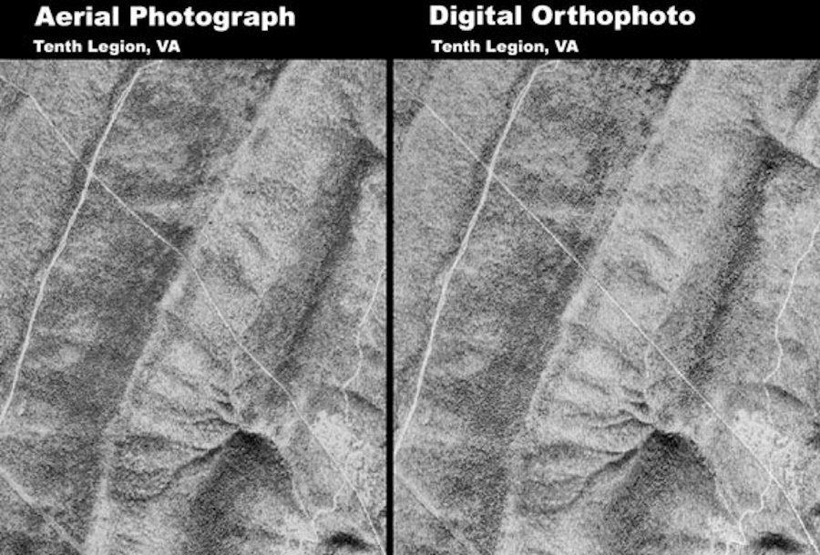
An example of orthorectification in action
The following image taken from the U.S. Geological Survey (USGS) is a great example of how orthorectification can show us more accurately what’s really happening on the ground. The two photos below show a pipeline running from top-left of each image to bottom-right. In the original aerial photograph on the left, the pipeline does not appear straight. A combination of camera tilting, lens distortion and ground topography conspired to show a distorted image. The orthorectified image on the right-hand side shows a more accurate representation of the straight pipeline.
Orthomosaics are immensely valuable tools in a whole variety of situations. Consider crop mapping with multispectral cameras, precise measurements of archaeological dig sites or progress charting of large civil engineering projects. If you have a project that could benefit from using orthomosaics then we’d love to hear from you. Call us on 01353 655762 or send an email to contact@foxvolant.com and we’d be happy to discuss your needs.