
Drone Survey and Aerial Photography Specialists
Welcome to the Fox Volant website. We provide drone survey and aerial photography services throughout the UK. Based near the beatiful city of Cambridge, we are well situated to travel the length and breadth of the country.
Continue reading to discover more about the services we offer, including terrain and volumetric surveys, inspections, agricultural services and aerial photography. If you’re looking to hire an experienced drone operator/pilot who is qualified, insured and authorised to operate by the CAA then get in touch using our contact form below.

Terrain Surveys
Traditional surveying methods can be both time-consuming and expensive or may be impractical due to the environment. A drone survey covers large areas of terrain quickly whilst capturing thousands of data points.
We will create two and three-dimensional maps of your site, showing the contours of the terrain as well as boundaries, ditches, buildings and other features.

Building Surveys and Inspections
Regular checks of your assets, whether a roof, cell tower, bridge or solar farm provide peace of mind. Inspections can also locate potential issues before they become major problems.
Our drone inspection service helps quickly locate areas of concern without the need for large areas of scaffolding or bringing in heavy machinery.

Volumetric Surveys
Knowing the volume of your stockpiles, earthworks or extracted materials helps you to stay on top of your site. Providing essential information for landfills, quarries or anywhere materials are stockpiled.
Using drones for volumetric surveys speeds up the data gathering process and improves accuracy by gathering more data points.

Aerial photography
Our qualified and experienced drone pilots will take stunning aerial photographs for your next project. The perfect addition to your online profiles, brochures and website.
Get in touch to ask about our aerial photography service or ask for a free quote using the contact form below.

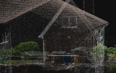
3D Modelling and Digital Twins
We are specialists in generating 3D Models and Digital Twins for use across a range of sectors. Using RTK enabled to drones to build accurate textured mesh and point cloud models for viewing online or importing into CAD or BIM applications.
For more information and to see examples of digital twins we’ve worked on, please use the link below.


Latest blog posts

Improving GPS accuracy with RTK
Most of us use GPS regularly, even if we are not all aware that we are doing so. But should we be concerned about its accuracy? In this post we consider when and how to go about improving GPS...

Fox Volant are now on Drone Safe Register
We are delighted to now be Gold Certified members of Drone Safe Register – the UK’s trusted network of trained, safe & insured professional drone pilots. Who are Drone Safe Register? Drone Safe...
I wandered lonely as a Point Cloud
In this post, we explain what point clouds are and why they're becoming an increasingly important part of day to day life across a multitude of industries. What are Point Clouds? Put simply, a point...
We are always interested in hearing about new projects, so please get in touch using the following form and tell us about your requirements.
We aim to respond to all queries promptly.